Tuesday, August 9, 2016

It has been a great run. By my very loose estimate, we have logged over 7 million conductivity observations in New England's lotic systems. Even more data are still arriving! It will be a long time before the knowledge these data can provide has been thoroughly exhausted.

Like the systems we study, though, the LoVoTECS Network has always been subject to the environment. The funding agreement with our EPSCoR partners has run its course and it is time to wrap up our study. Rather than allow LoVoTECS to die a slow death spread too thin across too large an area, we are consolidating our loggers on and around the Plymouth State University campus. We can then use the knowledge we've gained to assist graduate and undergraduate students with hands on field research while setting in place an intensive look at small scale watershed dynamics.

We did hope for a second funding wind to carry LoVoTECS into further seasons and richer data. However, we are still looking optimistically forward. Understanding the movement of chemistry through New England's hydrology is of critical importance to the future of our region. With the help of our hosts and partners, we have advanced that understanding. The future is bringing change, but it brings also new and exciting ways to further these advances.

To keep up on our new directions, as well as the great research being done in closely related work, visit the Center for the Environment at https://www.plymouth.edu/center-for-the-environment/. As always intended, LoVoTECS data will remain freely available in perpetuity. 


Wednesday, April 13, 2016

It’s been a crazy winter, but temperatures are on the rise, the lakes have completed their ice outs, and only dark, shelters ponds in scattered hollows remain frozen. The water is still numbingly cold, but we can now reach our loggers and we’re busily downloading data and changing our time stamps from the 15 minute over winter interval to a higher resolution 4 minute interval.

This was the first winter for our road salt study, and we’re very excited to see what the data tells us. We hope to add more on this in the near future after more of the data come in from the field.

It was great getting out to our hosts with the Hancock County Soil and Water Conservation District in Maine. I got to hear more about their sites and the water quality concerns they’re addressing Down East in cooperation with LoVoTECS. Their local area drains into coastal flats prized for fishing and clamming, increasing the importance of this data for their endeavors.


Owl Brook's silty bottom, bathed in spring sunshine.

Monday, March 21, 2016

Hi Everyone!!

My name is Anju Shrestha and I am an Environmental Science and Policy graduate student at Plymouth State University working to determine event-based variability in Phosphorus (P) concentration in stream water across storm event hydrographs in the Squam Lake watershed. Prior to joining the program, I graduated from Tribhuvan University, Kathmandu, Nepal with a Master of Science in Environmental Science.

P is the primary limiting nutrient, essential for the growth of algae in most freshwater aquatic systems.  The enrichment of P in rivers and Lakes can degrade the competition between different aquatic plant species which affects the whole ecosystem. The increase in P can even lead to algal blooms or eutrophication and deteriorate the quality of water. The streams and Lakes of New Hampshire are relatively cleaner than in other places but we cannot ignore the possibility of their degradation. So, timely study on P can make us aware and save our streams and lakes from eutrophication.

I have selected three different tributaries to the Squam Lake as my sites of interest. They are tributaries present in the North Brook, Livermore Cove and Dog Cove. I will be using discharge and specific conductivity data from the LoVoTECS Network. I will collect the water samples by using ISCO samplers before, during and after the storm events. The sampling periods will be set to catch the higher intensity and duration of precipitation events. The collected water samples will be tested in the laboratory of Plymouth State University to analyze Total Dissolved Phosphorus (TDP), Total Particulate Phosphorus (TPP) and Total Phosphorus (TP). Besides that, the water will be tested for other important parameters like pH, turbidity, conductivity, etc.

I will attempt to find the relation between TDP, TPP and TP with runoff in the streams. My research will also try to find whether specific conductivity and temperature obtained from LoVoTECS network are useful for explaining the variability of P in the stream. If they are found to be useful, this can lead to future research on how they affect the variability of Phosphorus.


My work will help to raise understanding, fulfill the gap of knowledge on P present in the tributaries of Squam Lake and increase awareness of eutrophication which can degrade the quality of water and wildlife present in a watershed. It will also help to monitor the trend of P concentration in stream water to Squam Lake.

LoVoTECS site modified for discharge
Photo by Anju Shrestha
            

Friday, December 18, 2015

Hello all,

Donovan here. We're wrapping up (no pun intended) for our holiday break and finishing off the fall semester here at Plymouth State University. In the spirit of tidying up loose ends, I'd like to give an update from the LoVoTECS team.

Ashley Inserillo has moved onward and upward to a career with the State of NH where she'll work to keep our drinking water safe. We wish her the best and thank her for the invaluable contributions she made while she was here.

Ashley's responsibilities will fall to myself and our new colleague, Dan Evans. Dan comes to us with a good deal of experience working with large hydrological data sets and with HOBO loggers specifically.

Our road salt sites are all deployed!

We have four sites in the White Mountain National Forest, with one site serving as a control along Bear Notch Road, which is closed, and not deiced, in winter. The other WMNF sites are along the Kancamagus Hwy and on NH 49 in Waterville Valley. Additionally, we have three road salt sites monitoring the Squam Lakes watershed, on NH 113, NH 258, and at the intersection of NH 175 and US 3. Lastly, we will be monitoring NH 25's impact on Clay Brook in Plymouth.

We're excited that we managed to install all sites before any salt was used this season.

Our Road Salt sites can be found in our Google Map. Simply view the Road Salt Locations layer, or take note of the dark blue locations among all active sites.
LoVoTECS Locations

This phase of the LoVoTECS experience will be coming to an end in August. We're excited with the data you've all provided and now must compile it into the many stories it wants to tell. Look for updates as these stories come together.

Thank you, volunteers and partners, for all you do and all you've done. Like our loggers, we hope spring finds you safe, functional, and rich with memories.

Thursday, October 29, 2015

Hey everyone!

I am Donovan King, a biologist, and I joined the LoVoTECS team as a field technician a few months ago after finishing my MS with Plymouth State University.

We have some exciting new work emerging for our LoVoTECS network.

We are currently in the process of moving our research upstream. We will continue to analyze the valuable data we obtained from all of your sites, but we are shifting our focus to the White Mountain tributaries. We will be further exploring the intrusion of road salt into streams at road crossings beginning this 2015/16 winter.

The Cary Institute notes that New Hampshire was the pioneer of using salt to deice our roadways, beginning our first experimental treatments in 1938. The ingenuity has made our highways safer and undoubtedly saved countless lives, but not without environmental consequences. Excess salt poses a risk to our stream ecosystems and contaminates the ground water feeding municipal drinking wells and reservoirs. Today, in the White Mountain region alone, we apply some 25 thousand tons of salt each year to maintain driving conditions on state roads and, likely in response to changing weather patterns, our annual road salt use has been increasing. Local roads and private landholders contribute even more, though the exact amounts are hard to ascertain.

Understanding how the direct input of salt from the road and the legacy salt of previous seasons leeching from soils and ground water interact is crucial to informed policy making. Our new research will attempt to isolate background ions – resulting from natural weathering - from the contribution of ions from deicing salts and pair this information with stream flow rates. To do this, we are installing standardized road salt monitoring sites with paired upstream and downstream sensors placed at prescribed distances from the road (see figure below). We hope to have all sites installed and collecting data prior to the 2015/2016 ice over.


 In the Squam Lakes region, we are pairing our research with that of two new graduate students:

Rebecca Hanson is with the Squam Lakes Association. They have been monitoring water quality in the Squam Lake since 1979. She hopes to expand monitoring to our tributaries and examine modern threats to water quality, such as impacts from road salt application. This will better help the SLA to achieve their mission to protect the Squam Lakes and Watershed. Information gathered from this study will help to inform the updated Squam Watershed Plan, and enable them to not just monitor the lakes, but to take action in restoration and protection.

Anju Shrestha is researching a proof of concept to monitor phosphorous input into the lake. She will attempt to pair specific conductivity to phosphorous loading in the streams. If successful, this could improve the usefulness of our data collection methods.

We will be installing at least two of our standardized road salt monitoring sites on Squam Lake tributaries (see map below). Salt use along the northern watershed of Squam Lake, Rt. 113, has been increasing since 1997. Then, an average of 6.98 tons of salt per lane mile was applied. In 2015, the average salt per lane mile has more than doubled to 15.96 tons.

Map of Squam Lakes Sites

In contrast, the Tenney Mountain Hwy (Rt. 25) has seen a sporadic history of annual salt application from as little as 15 to as much as 30 tons per lane mile, with no noticeable change over the last 18 years. Here, we have installed a standardized monitoring site in Clay Brook.

The west end of the Kancamagus (Rt. 112) will also receive several standardized monitoring sites, though the exact locations are still being explored. We hope in the coming weeks to have chosen some informative locations so we can begin to collect data. The Kancamagus is exciting because road salt use is on the decline for NH’s famous roadway; from >20 tons per lane mile in the late 90s and peaking at 43 in 2003, application rates have been down to the teens for the last three years.

Friday, May 8, 2015

Snapshot Results from 2013 & 2014

Happy Spring Everyone!
Please follow this link to view the LoVoTECS Snapshot results from Summer 2013 and 2014. Feel free to ping us with any questions!

Tuesday, December 2, 2014

LoVoTECS expands into coastal Maine to investigate beach & shellfish flat closures


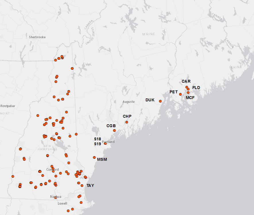
Last year, Plymouth State University was the partial recipient of a grant from the National Science Foundation to integrate research across state lines.  As a result, LoVoTECS expanded its network into coastal Maine in order to investigate water quality related to closure of beaches and shellfish flats (http://www.newenglandsustainabilityconsortium.org/safe-beaches-shellfish).  We are excited to welcome our new partners, who include: the Hancock & Cumberland County Soil and Water Conservation Districts, City of Ellsworth, Kennebec Esutary Land Trust, UMaine Cooperative Extension/Tanglewood 4-H Camp, Coastal Studies for Girls and the Town of Hampton!

Below is a list of the new sites installed this field season: 
1.   Mousam River, Kennebunk, ME  (MSM)
2.  Card Brook, Ellsworth, ME (CAR)
3.  McFarland Brook, Trenton, ME (MCF)
4.  Flood Steam, Surry, ME (FLD)
5.  Peters Brook, E. Blue Hill, ME (PET)
6. Long Creek, Portland, ME (2 sites: S18, S19)
7. Concord Gully, Freeport, ME (CGB)
8.  Merrymeeting Bay/Chopps Point, Woolwich , ME (CHP)
9.  Ducktrap River, Lincolnville, ME (DUK)
10. Taylor River, Hampton, NH (TAY)


Our data will help provide information for other interests besides beach and shellfish closures- Check out the restoration project at Long Creek site: http://www.restorelongcreek.org/