Tuesday, December 2, 2014

LoVoTECS expands into coastal Maine to investigate beach & shellfish flat closures


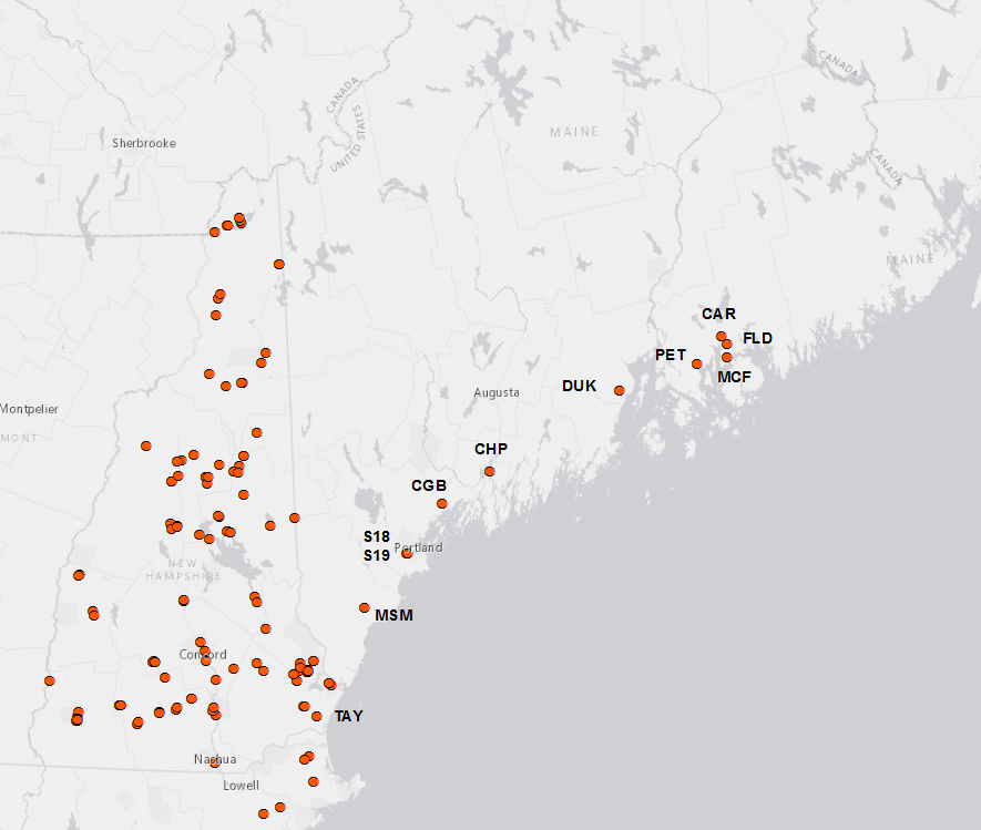
Last year, Plymouth State University was the partial recipient of a grant from the National Science Foundation to integrate research across state lines.  As a result, LoVoTECS expanded its network into coastal Maine in order to investigate water quality related to closure of beaches and shellfish flats (http://www.newenglandsustainabilityconsortium.org/safe-beaches-shellfish).  We are excited to welcome our new partners, who include: the Hancock & Cumberland County Soil and Water Conservation Districts, City of Ellsworth, Kennebec Esutary Land Trust, UMaine Cooperative Extension/Tanglewood 4-H Camp, Coastal Studies for Girls and the Town of Hampton!

Below is a list of the new sites installed this field season: 
1.   Mousam River, Kennebunk, ME  (MSM)
2.  Card Brook, Ellsworth, ME (CAR)
3.  McFarland Brook, Trenton, ME (MCF)
4.  Flood Steam, Surry, ME (FLD)
5.  Peters Brook, E. Blue Hill, ME (PET)
6. Long Creek, Portland, ME (2 sites: S18, S19)
7. Concord Gully, Freeport, ME (CGB)
8.  Merrymeeting Bay/Chopps Point, Woolwich , ME (CHP)
9.  Ducktrap River, Lincolnville, ME (DUK)
10. Taylor River, Hampton, NH (TAY)


Our data will help provide information for other interests besides beach and shellfish closures- Check out the restoration project at Long Creek site: http://www.restorelongcreek.org/

New Graduate Student

Hi everyone!
Baker River, Plymouth NH
Photograph by Lisa Scott

My name is Dan Demers and I’m an Environmental Science and Policy graduate assistant at Plymouth State University working with data from the LoVoTECS Network.

Prior to joining the program, I graduated from Westfield State University in 2011 with a Bachelor’s of Science in Environmental Science and worked in a semi-volatile organic compound laboratory in Western Massachusetts.

Currently, I am looking at the characteristics of specific electrical conductance (SpEC) at certain LoVoTECS sensor sites. SpEC is electrical conductance (which is measured by the black, HOBO U24 sensors) after it has been corrected for the temperature of the water. It is a measure of how well water conducts electricity, increasing with the addition of dissolved solids. Pure, deionized water does not conduct electricity at all, so this measurement can help us learn about the presence and movement of ions within our streams.

Here in New Hampshire, road salt is one of the key factors that increases the SpEC of water, but it isn’t the only material that does this, as you can see from the 2013 and 2014 snapshot results (link coming soon). If the SpEC conductance of water becomes too high, it can affect organisms living in the stream.

Usually when a storm occurs, the SpEC in a stream dilutes with the addition of the new rain-water. However, during the beginning of some storm events, at some sensor sites, the SpEC will briefly increase before diluting. This increase, caused by a flushing of solutes into the stream (known as first flush), can be quite large in some instances, even reaching levels which can have an acute effect on lotic organisms.

I’m specifically looking at sensor sites in the network that exhibit this first flush behavior in order to analyze how the events are affected by seasonality, storm intensity, and the environmental conditions since a previous storm. Essentially this means that I’m studying how time affects the ways in which solute flushing events occur and behave.

Going forward, I hope to be able to accurately predict the presence, duration, and magnitude of solute flushing at certain sites. This knowledge will increase understanding of how water and solutes are transported within our local environment and will be able to indicate which environmental conditions might lead to SpEC-related problems for some lotic organisms’ well-being.